 New Page 1
|
Relief
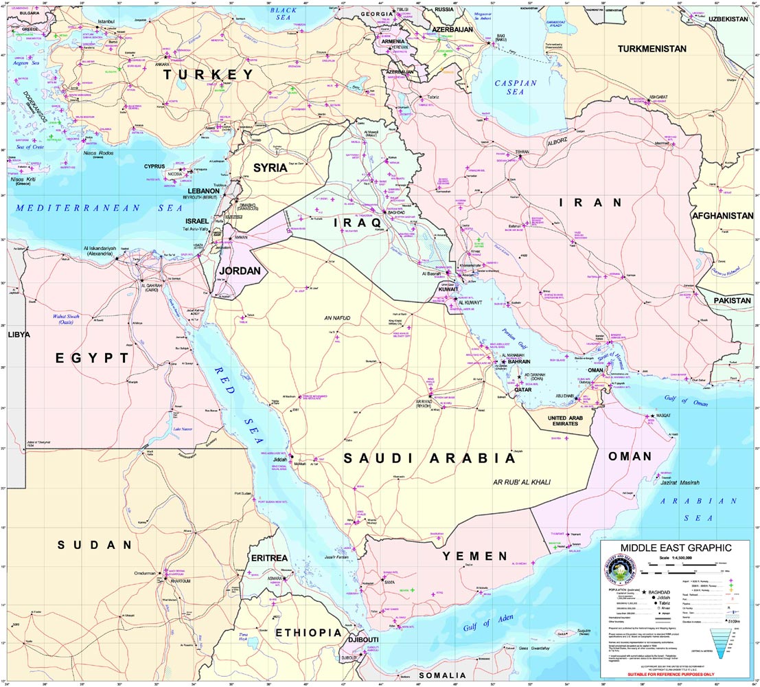
Iraq is uniquely positioned at the
heart of the Middle East, between latitudes 2927' and 3723' North and
longitudes 3842' and 4823' East. It is bounded by Iran in the east, Turkey
in the north, Syria in the northwest, Jordan and Saudi Arabia in the west
and southwest, and Kuwait and the Gulf in the south. The country's
greatest axis, running in a north-northwest to south-southeast direction
from the Turkish border to the shores of the Gulf, is almost 1,000 km.
Iraq is traversed by two great
rivers, the Tigris and the Euphrates, both of which rise in the eastern
mountains of Turkey and enter Iraq along its northwestern borders. After
flowing for some 1,200 km through Iraq, these two rivers converge at
Karmat Al, just north of Basrah, to form the tidal Shatt Al Arab waterway,
which flows some 110 km to enter the Gulf. The Euphrates does not receive
any tributaries within Iraq, while the Tigris receives four main
tributaries, the Khabour, Great Zab, Little Zab and Diyala, which rise in
the mountains of eastern Turkey and northwestern Iran and flow in a
southwesterly direction until they meet the Tigris River. A seasonal
river, Al Authaim, rising in the highlands of northern Iraq also flows
into the Tigris, and is the only significant tributary arising entirely
within Iraq.
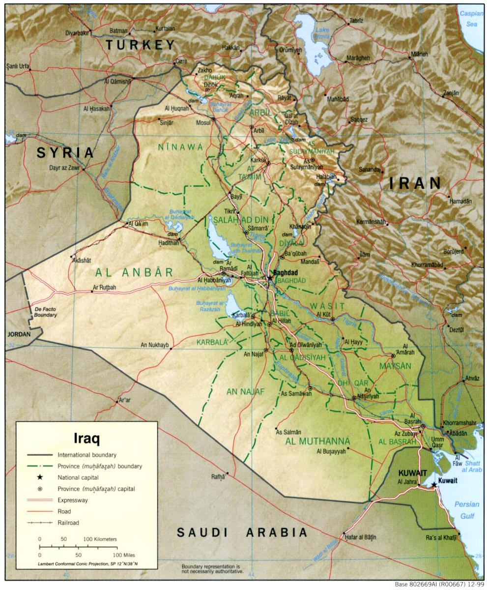
Most geographers, including those of the Iraqi government, discuss the
country's geography in terms of four main zones or regions: the highlands
“mountain region” in the north and northeast; the upper plains and
foothills region, or the rolling upland between the upper Tigris and
Euphrates rivers (in Arabic the Dijla and Furat, respectively); the
alluvial plain through which the Tigris and Euphrates flow; and the desert
in the west and southwest. Iraq's official statistical reports give the
total land area as 438,446 square kilometers, whereas a United States
Department of State publication gives the area as 434,934 square
kilometers.

The mountain region
This extends from the northern and northeastern frontiers of Iraq on the
borders of Turkey and Iran south to a line from Sinjar in Mosul Province
to Zakho, Dohuk, Arbil, Kirkuk, Tuz, Kifri and finally Halabja on the
Iranian border. Heights range from 900 to 3,660 m.
The upper plains and foothills
region
This steppic sub-mountain belt extends from the high mountains to the
foot of Jabal Hemrin, and forms a transitional area between the highland
areas and the desert plains.
The desert plateau region
The desert plateau comprises the largest part of Iraq (almost 57% of the
total land area), and extends from the edge of the upper plains and
banks of the Euphrates River to the frontiers with Syria, Jordan and
Saudi Arabia. Conditions grade from semi-desert (the upper Jazirah,
especially the area between the Tigris and Euphrates below Jabal Hemrin)
to a more typical sandy desert in the far south and west.
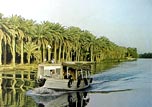
The lower valley
The great alluvial plains of the Tigris and Euphrates Rivers comprise
about 25% of Iraq's surface area. Topographically, this region is
composed of marshlands and low-lying plains dissected by sluggish
drainage channels. The whole area is extremely flat, with a fall of only
4 cm/km over the last 300 km of the Euphrates and 8 cm/km along the
Tigris. Thus, the annual flooding, which may be in the order of 1.5 to 3
meters, regularly inundates immense areas of land (the highest flood
ever recorded was 9 meters on the Tigris in 1954). As a result, much of
the region is swampy. At the height of the flood season in spring,
virtually all of the land in the triangle Basrah-Amara-Nasiriya was
formerly one expanse of continuous marshland, while in the dry season
there remained numerous large permanent lakes and extensive reed beds
inter-connected by an intricate network of channels. In recent years,
the seasonal flooding has occurred on a much smaller scale than before
because of intensive water regulation by dams upstream on the Tigris and
Euphrates and especially on the Euphrates in Turkey and Syria.
The desert zone, an area lying west and southwest of the Euphrates River,
is a part of the Syrian Desert, which covers sections of Syria, Jordan,
and Saudi Arabia. The region, sparsely inhabited by pastoral nomads,
consists of a wide, stony plain interspersed with rare sandy stretches. A
widely ramified pattern of wadis--watercourses that are dry most of the
year--runs from the border to the Euphrates. Some Wadis are over 400
kilometers long and carry brief but torrential floods during the winter
rains.
The uplands region, between the Tigris north of Samarra and the Euphrates
north of Hit, is known as Al Jazirah (the island) and is part of a larger
area that extends westward into Syria between the two rivers and into
Turkey. Water in the area flows in deeply cut valleys, and irrigation is
much more difficult than it is in the lower plain. Much of this zone may
be classified as desert.
The northeastern highlands begin just south of a line drawn from Mosul to
Kirkuk and extend to the borders with Turkey and Iran. High ground,
separated by broad, undulating steppes, gives way to mountains ranging
from 1,000 to nearly 4,000 meters near the Iranian and Turkish borders.
Except for a few valleys, the mountain area proper is suitable only for
grazing in the foothills and steppes; adequate soil and rainfall, however,
make cultivation possible. Here, too, are the great oil fields near Mosul
and Kirkuk. The northeast is the homeland of most Iraqi Kurds.
The alluvial plain begins north of Baghdad and extends to the Persian
Gulf. Here the Tigris and Euphrates rivers lie above the level of the
plain in many places, and the whole area is a delta interlaced by the
channels of the two rivers and by irrigation canals. Intermittent lakes,
fed by the rivers in flood, also characterize southeastern Iraq. A fairly
large area (15,000 square kilometers) just above the confluence of the two
rivers at Al Qurnah and extending east of the Tigris beyond the Iranian
border is marshland, known as Hawr al Hammar, the result of centuries of
flooding and inadequate drainage. Much of it is permanent marsh, but some
parts dry out in early winter, and other parts become marshland only in
years of great flood.
Because the waters of the Tigris and Euphrates above their confluence are
heavily silt laden, irrigation and fairly frequent flooding deposit large
quantities of salty loam in much of the delta area. Windborne silt
contributes to the total deposit of sediments. It has been estimated that
the delta plains are built up at the rate of nearly twenty centimeters in
a century. In some areas, major floods lead to the deposit in temporary
lakes of as much as thirty centimeters of mud.
The Tigris and Euphrates also carry large quantities of salts. These, too,
are spread on the land by sometimes excessive irrigation and flooding. A
high water table and poor surface and subsurface drainage tend to
concentrate the salts near the surface of the soil. In general, the
salinity of the soil increases from Baghdad south to the Persian Gulf and
severely limits productivity in the region south of Al Amarah. The
salinity is reflected in the large lake in central Iraq, southwest of
Baghdad, known as Bahr al Milh (Sea of Salt). There are two other major
lakes in the country to the north of Bahr al Milh: Buhayrat ath Tharthar
and Buhayrat al Habbaniyah.
The Euphrates originates in Turkey, is augmented by the Nahr (river) al
Khabur in Syria, and enters Iraq in the northwest. Here it is fed only by
the wadis of the western desert during the winter rains. It then winds
through a gorge, which varies from two to sixteen kilometers in width,
until it flows out on the plain at Ar Ramadi. Beyond there the Euphrates
continues to the Hindiyah Barrage, which was constructed in 1914 to divert
the river into the Hindiyah Channel; the present day Shatt al Hillah had
been the main channel of the Euphrates before 1914. Below Al Kifl, the
river follows two channels to As Samawah, where it reappears as a single
channel to join the Tigris at Al Qurnah.
The Tigris also rises in Turkey but is significantly augmented by several
rivers in Iraq, the most important of which are the Khabur, the Great Zab,
the Little Zab, and the Uzaym, all of which join the Tigris above Baghdad,
and the Diyala, which joins it about thirty-six kilometers below the city.
At the Kut Barrage much of the water is diverted into the Shatt al Gharraf,
which was once the main channel of the Tigris. Water from the Tigris thus
enters the Euphrates through the Shatt al Gharraf well above the
confluence of the two main channels at Al Qurnah.
Both the Tigris and the Euphrates break into a number of channels in the
marshland area, and the flow of the rivers is substantially reduced by the
time they come together at Al Qurnah. Moreover, the swamps act as silt
traps, and the Shatt al Arab is relatively silt free as it flows south.
Below Basra, however, the Karun River enters the Shatt al Arab from Iran,
carrying large quantities of silt that present a continuous dredging
problem in maintaining a channel for ocean-going vessels to reach the port
at Basra. This problem had been superseded by a greater obstacle to river
traffic, however, namely the presence of several sunken hulks that had
been rusting in the Shatt al Arab since early in the war.
The waters of the Tigris and Euphrates are essential to the life of the
country, but they may also threaten it. The rivers are at their lowest
level in September and October and at flood in March, April, and May when
they may carry forty times as much water as at low mark. Moreover, one
season's flood may be ten or more times as great as that in another year.
In 1954, for example, Baghdad was seriously threatened, and dikes
protecting it were nearly topped by the flooding Tigris. Since Syria built
a dam on the Euphrates, the flow of water has been considerably diminished
and flooding was no longer a problem in the mid-1980s. In 1988 Turkey was
also constructing a dam on the Euphrates that would further restrict the
water flow.
Until the mid-twentieth century, most efforts to control the waters were
primarily concerned with irrigation. Some attention was given to problems
of flood control and drainage before the revolution of July 14, 1958, but
development plans in the 1960s and 1970s were increasingly devoted to
these matters, as well as to irrigation projects on the upper reaches of
the Tigris and Euphrates and the tributaries of the Tigris in the
northeast. During the war, government officials stressed to foreign
visitors that, with the conclusion of a peace settlement, problems of
irrigation and flooding would receive top priority from the government.
Boundaries
The border with Iran has been a continuing source of conflict and was
partially responsible for the outbreak in 1980 of the present war. The
terms of a treaty negotiated in 1937 under British auspices provided that
in one area of the Shatt al Arab the boundary would be at the low water
mark on the Iranian side. Iran subsequently insisted that the 1937 treaty
was imposed on it by "British imperialist pressures," and that the proper
boundary throughout the Shatt was the thalweg. The matter came to a head
in 1969 when Iraq, in effect, told the Iranian government that the Shatt
was an integral part of Iraqi territory and that the waterway might be
closed to Iranian shipping.
Through Algerian mediation, Iran and Iraq agreed in March 1975 to
normalize their relations, and three months later they signed a treaty
known as the Algiers Accord. The document defined the common border all
along the Shatt estuary as the thalweg. To compensate Iraq for the loss of
what formerly had been regarded as its territory, pockets of territory
along the mountain border in the central sector of its common boundary
with Iran were assigned to it. Nonetheless, in September 1980 Iraq went to
war with Iran, citing among other complaints the fact that Iran had not
turned over to it the land specified in the Algiers Accord. This problem
has subsequently proved to be a stumbling block to a negotiated settlement
of the ongoing conflict.
In 1988 the boundary with Kuwait was another outstanding problem. It was
fixed in a 1913 treaty between the Ottoman Empire and British officials
acting on behalf of Kuwait's ruling family, which in 1899 had ceded
control over foreign affairs to Britain. The boundary was accepted by Iraq
when it became independent in 1932, but in the 1960s and again in the
mid-1970s, the Iraqi government advanced a claim to parts of Kuwait.
Kuwait made several representations to the Iraqis during the war to fix
the border once and for all but Baghdad has repeatedly demurred, claiming
that the issue is a potentially divisive one that could enflame
nationalist sentiment inside Iraq. Hence in 1988 it was likely that a
solution would have to wait until the war ended.
In 1922 British officials concluded the Treaty of Mohammara with Abd al
Aziz ibn Abd Al Rahman Al Saud, who in 1932 formed the Kingdom of Saudi
Arabia. The treaty provided the basic agreement for the boundary between
the eventually independent nations. Also in 1922 the two parties agreed to
the creation of the diamond-shaped Neutral Zone of approximately 7,500
square kilometers adjacent to the western tip of Kuwait in which neither
Iraq nor Saudi Arabia would build permanent dwellings or installations.
Bedouins from either country could utilize the limited water and seasonal
grazing resources of the zone. In April 1975, an agreement signed in
Baghdad fixed the borders of the countries. Despite a rumored agreement
providing for the formal division of the Iraq-Saudi Arabia Neutral Zone,
as of early 1988 such a document had not been published. Instead, Saudi
Arabia was continuing to control oil wells in the offshore Neutral Zone
and had been allocating proceeds from Neutral Zone oil sales to Iraq as a
war payment.
|